Tuesday, 19 August 2014

KERALA with a delightful twist!

  • KERALA with a delightful twist!
  • Kerala with its culture and traditions, coupled with its varied demographics, have made Kerala one of the most popular tourist destinations in India. National Geographic's Traveller magazine names Kerala as one of the "ten paradises of the world" and "50 must see destinations of a lifetime".Travel and Leisure names Kerala as "One of the 100 great trips for the 21st century". In 2012, it overtook Taj Mahal to be the number one travel destination in Google's search trends for India. Kerala's beaches, backwaters, mountain ranges and wildlife sanctuaries are the major attractions for both domestic and international tourists. The city of Kochi ranks first in the total number of international and domestic tourists in Kerala.


  • Geography

    With the Arabian Sea in the west, the Western Ghats towering 500-2700 m in the east and networked by forty-four rivers, Kerala enjoys diverse geographical features. Kerala is divided into three geographical regions: Highlands, which slope down from the Western Ghats onto the Midlands of undulating hills and valleys into an unbroken coastline with many picturesque backwaters, interconnected with canals and rivers. The Western Ghats are nowhere more than 120 kms from the sea.
    • People and Life

      Kerala is one of India's most progressive states in terms of social welfare and quality of life. The State boasts of one of India's highest literacy rates, highest life expectancy and lowest child mortality rates. The literacy rate for women is one of the highest in all of Asia. Enjoying a unique cosmopolitan viewpoint, the people of Kerala, at all levels of society, have greater access to services and opportunities - as well as a greater say in their governance.
      • Location

        Kerala is situated on the southwestern coast of India, a country in South Asia. This tropical paradise enjoys a unique topography with Arabian sea, a part of the Indian Ocean on the west and the Western Ghats on the east.

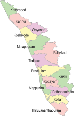
        Districts

        Kerala Map
      • Major Cities

        Thiruvananthapuram
        Kollam
        Kochi
        Thrissur
        Kozhikode

        Airports

        Thiruvananthapuram International Airport
        Cochin International Airport (CIAL), Nedumbassery
        Calicut International Airport, Karipur
    • History

      Kerala's history is closely linked with its commerce, which until recent times revolved around its spice trade. Celebrated as the Spice Coast of India, ancient Kerala played host to travelers and traders from across the world including the Greeks, Romans, Arabs, Chinese, Portuguese, Dutch, French and the British. Almost all of them have left their imprint on this land in some form or the other - architecture, cuisine, literature
  • Seasons

    Bestowed with a pleasant and equable climate throughout the year, Kerala is a tropical land with the coast running down its entire length and the Western Ghats forming a protective barrier against the dry winds from up north. The monsoons (June-September & October-November) and summer (February-May) are the seasons markedly experienced here, while winter is only a slight drop in temperature from the normal range of 28-32°C

Off Beat Tourist Destinations!!

MUST VISIT OFF BEAT TOURIST SPOTS

.

KHAJJIAR


This quiet and tranquil place with scenic  beauty is located in Himachal Pradesh near Chamba and Dalhousie.  It is about 6,500 feet (2,000 m) above sea level in the foothills of the Dhauladhar ranges of the Western Himalayas and snowy peaks can be seen in the distance. It is part of the Kalatop Khajjiar Sanctuary. An incredible place in itself where three ecosystem- the lakes, the pastures, the forests come together to make the experience more beautiful.
Mr Willy T Blazer,  Vice Counselor and Head of Chancery of Switzerland  christened this as  “Mini Switzerland of India.” on 7 July 1992.


How to reach:
  • Accessibility by road: It is one one and a half km drive from Dalhousie and Chamba. Himachal Road Transport Corporation operates bus service connecting Khajjiar with major cities in the state.
  • Accessibility by train: Nearest railway station is Pathankot. It is 80 km drive from there to Khajjiar.
  • Accessibility by Air: Nearest airport is in Pathankot which is 80 km away from here and Gaggal in Kangra which is 180 km far from here.


Best time to visit:
It is snow covered in winters, the temperature dips down to -1 degree Celsius The summers are pleasant. Best time to visit is from mid September to November.

Where to Stay
  • Hotel Royal Residency
  • Hotel Hritik Palace
  • Hotel Shining Star
  • Hotel Mini Swiss


Where to go? What to do?
  • Khajjiar Lake : It has a floating island which takes you by awe.  Long walks by the lake side is a pleasure to the eyes and kids can enjoy rolling down and playing here.
  • Paach Pandav Tree: The main root of tree is same but its base is devided into six parts. There is another deodar tree which has one root but base devided into 13. This is called “Mother tree”


  • Khajji Nag Temple: Khajjiar Is Famous For The Popular Khajji Naga Temple At Khajjiar Main Ground. Shrine Is Dedicated To The Serpent God From Which The Name Is Believed To Have Been Derived. The Temple Dates Back To The 10th Century And Is Inter Spaced With Different Patterns And Images On The Ceiling And Wooden Posts. A Curious Blend Of Hindu And Mughal Styles Of Architecture Is Reflected In The Wooden Carvings On The Ceilings And Wooden Posts. The Image Carvings Are Said To Represent The Kauravas Who Were Tied Up Here In The Hideout By The Pandavas. The Temple Consists Of A Spacious Congregation Hall Sufficiently Enclosed By Wooden Supports. The Dome-shaped Shrine Is Made Of Slates Locally Extracted From Limestone Quarries. Adjoining Are Other Shrines Of Shiva And Hadimba Goddess Also. The Age-old Tradition Of Sacrificing A Goat Is Still Practiced Outside The Temple Premises.


DRASS


Drass, also known as ‘Gateway to Ladakh’ and is the second coldest inhabited region in the world. The temperature here drops down to 60 degree celsius. It is located 60 km west from ladakh, starts from the foot of Zoji la Pass. It has an elevation of 10,674 km from the sea level.


How to reach:
  • Accessibility by road
Srinagar is connected to Kargil/ Drass sector via National HIghway 1. There are local buses plying between Srinagar and Kargil that passes through Drass sector.
  • Accessibility by rail
Nearest railway station is Jammu Tawi railway station. From there you can hire a cab.
  • Accessibility by Air:
There is an airport in Leh, from there you can take local bus or cab to reach Drass.


Best time to visit:
Summer season that is from May to September is the best time to visit Drass.


Where to stay:
There are tourist complex which have well furnished guest house and suites. There are some private hotels too which provide basic room and necessities.


Tourist Attractions:
  • Dras War Memorial:
Constructed to commemorate the martyrs of Kargil War.
  • Draupadi Kund:
It is believed that Draupadi, the protagonist of Mahabharata took her final bath before dying in Himalayas.


  • Mushko Valley:
Fantastically beautiful stretch of lush green land with wild flowers.


SANDAKPHU


If you love treking then Sandakhpu should be on top of your list. It is located at North West of Darjeeling at height of 12,000 ft.Sandakhpu means ‘height of poison plant’  It can be a tiring trek but once you reach there you are welcomed by an enchanted scenic view. From Sandakhpu you get a 180 degree view of Eastern Himalayas, with ranges that belong to Nepal on the west, Sikkim and Bhutan in the middle and Arunachal Pradesh in the east.  


How to reach?
  • Accessibility by Road:
Sandhakpu is 58 km away from Darjeling. The road is constricting you can either go by Jeep or Land Rover or go treking from Manhebhajan.
Trek at glance: Manebhanjung – Tonglu
Tonglu – Joubari – Garibas
Gairibas – Kalpokhri
Kalpokhri – Vivekbhanjan – Sandakphu
Sandakphu – Kalpokhri – Rimbik
Rimbik – Jhepi
Jhepi – Kaijala – Darjelling.
The treks is amidst many forests, you get to see as many as 500 species of plants and the natural beauty is commendable.
  • Aceessibiltiy by Rail:
The nearest railway station is Jalpaiguri
  • Aceessibility by Air:
The nearest airport is Bagdogra.


Where to live?
There are GTA Trekkers huts which provide you with basic accomodation. You can make booking online through www.gtatourism.com
There are other private hotels too like Hotel Sharpa Chalet, which gives a view of Kanchenjunga peaks. Then there is Hotel Sunrise, Namo Budha Hotel.

Best time to visit
Best time to travel is April to May and September to October.


Tourist Attraction:


It is the only place where you get panaromic view of the world’s five highest peaks, the spectacular 8000 m magnificence- Everest, Kanchenjunga, Makalu and Lhotse in a continuous snow-clad curve. Besides these the adjoining peaks are also clearly visible- Napse, Koktang, Janu, Kumbhakarna, Kabru South, Kabru North, Pandim, Narsing, Naulekh, Chamlang and Dom Makheri. In the months of April and May an abundance of flowers make Sandakphu even more beautiful.
In far West from here you can see the mighty Mount Everest (29,029 ft., the highest peak in the world) and the Everest family. You will find it along with other peaks like Lhotse (27940 ft., the fourth highest peak) and Mt. Makalu (27,825 ft, the fifth highest peak). If you look further west, you will see the Chamlang (24,006 ft) that stands like a square wall of snow.
Turn towards east at Sikkim, you will see the striking and prominent peaks of Kanchenjunga family (summit 28,156 ft., the third highest peak in the world). Other peaks close to Kanchenjunga include Kabru (24,026 ft), Kumbhakarna (25,294 ft.) and Pandim (22,010 ft). Between Everest and Kanchenjunga you will see the peaks of Three Sisters.
If you look further east of Kanchenjunga, you will see the great Tibetan peaks of Narsing, Dongkya and Chola. And then you can spot Chamolhari in Bhutan.
Monday, 18 August 2014


INDIA'S UNDISCOVERED GEM: THE HILLS OF MEGHALAYA
 
      https://encrypted-tbn2.gstatic.com/images?q=tbn:ANd9GcTPWjvH9Ny777B7nQa9ZkJAetClzpVbCKr5MIAbxQMcWrUTDA1A


Meghalaya seems to be somewhat of a forgotten paradise... perhaps that is because it is the wettest place on earth and is often shrouded in fog... In fact the name means "abode of the clouds"...
Nestled in the hills of eastern sub-Himalayas is Meghalaya is one of the most alluring states in the country. It is blessed with abundant rainfall, sun-shine, virgin forests, high plateaus, crystal clear rivers, tumbling waterfalls, meandering streamlets and above all with hardy, intelligent and hospitable people.


Meghalaya is a storehouse of richly varied and colourful orchids with as many as 325 species, which grow all over the Khasi, Jaintia, and Garo Hills in the meadows, hill-slopes, and swamps, even on the wayside.


https://encrypted-tbn1.gstatic.com/images?q=tbn:ANd9GcSJeyYkSqigHKqJKYEls5OvZN7eIJrYqpNosXUHf-jGvsXJtjQM
The local market place, characterised by criss-crossing narrow alleyways, often allowing only one person to pass at a time, is a world in itself. It’s a street photographer's dream come true! One can easily get lost in this labyrinth selling all things under the sun for everyday needs, and there are whole alleys specialising in one single product- from obvious fruits, vegetables to kitchen utensils, cane furniture, fish, all kinds of meat, grocery, cloth, sweets. Morning hours are the best time to see the entire buzz, consider having breakfast in one of the alleys serving poori-bhaji.


The village also has a couple of restaurants to cater to travellers visiting them during lunch hours. The Menu is fairly simple. There are a couple of families also who run just simple tea & lunch service made within their home kitchen.


The Mawsmai cave is one of the caves one mustn’t give a miss to. The caves have been looked after by the tourism department and can provide good fun to beginners interested in cave explorations, or even regular travellers who are interested in a little adventure. The cave is about 800 ft long, well lit and over all easy to navigate.


A part of the cave is made up of glistening stones shining in the light reflecting on it. Very near to this part is also a natural opening in the roof, letting some natural light in, which not only provides an enchanting visual, but also relief to those feeling eerily awe-struck.


Mawlynnong is a village in East Khasi Hills district of Meghalaya and at a distance of about 90 km from Shillong.  It was Discover India magazine in 2003 and then later on BBC in 2005 and 2009, which first claimed Mawlynnong to be Asia's Cleanest Village.


Another very important and significant aspect is that this village is 100% literate i.e. each person in the village can read and write. Young ones are all sent to school and are fairly conversant in English. Another matter of great significance is that every single house has a toilet. And well, we pretty much know that's no mean feat in country like India where majority of the population is still reeling under poverty.


The people of the village are shining examples of how you don't need massive equipment or stifling procedures to make a difference to your environment or to protect the local ecology. The two schools in the village have durable, clean toilets and drinking water with tanks, which is something very rare in village schools in the country. Cleanliness seems to be a habit passed on from generations!
 
 
The village boasts of clean cemented paved pathways, dustbins made of bamboo at every corner, separate pits to make compost out of green waste, ban on plastics, environment friendly housing and structures, well defined piped water supply, gardens in an already very green habitat.


Ever wondered where the Indian household's quintessential broom came from?
It’s typically from these regions of East Khasi Hills, where it is grown, in form of a grass, in abundance. One can take a walk out of the village and visit these plantations which cover several kilometres on either side of main road.


All Khasi villages are connected by a network of stone pathways known as the King’s way which traditionally kept the local betel nut trade alive with Shillong.  Throughout this network, hundreds of living root bridges form the bridleways over the myriad of water channels that criss-cross the area.  A few minutes walk from Mawlynnong is what I consider to be the most beautiful of all the bridges in the East Khasi Hills, namely the bridge at Wahthyllong. The view from above reveals the majesty of this masterpiece.  Over the years, stones and earth have been lodged between the gaps of the banyan tree roots to form the beautiful pathway and underneath, the ancient organic mesh work weaves its beauty.


Another short hike, and one can witness one of world's most amazing and unique phenomenon, the living root bridges. These bridges are made out of thick entangled roots growing out of Ficus Elastica tree. Mawlynnong and Cherrapunji are counted among world's wettest places and hence the greenery, vegetation and forest cover is really dense. The Khasi people living in these forested areas over centuries discovered this tree which had several secondary roots growing out over ground level and they quickly turned it into a growing bridge, connecting two raised banks separated by one of the several streams within the area. These bridges are extremely sturdy and are made walkable by fitting smooth rock boulders through it. It can take up to 15 years for a bridge to become fully functional. And for those in need of more adventure there is a double-decker living root bridge at Cherrapunji, which can be reached after about 2-3 hour hike.

 
A picturesque but tiny state that has remained cut off from mainstream India for a long time due to some ethnic problems, Meghalaya has been able to survive the onslaught of crass commercialization that has taken over other famous tourist centres of India.